Langar Conservation Area
Langar Conservation Area Appraisal and Management Plan February 2023

Contents
1.1 Conservation Areas
1.2 The Purpose of a Conservation Area Character Appraisal
1.3 The Planning Policy Context
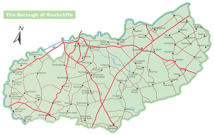
2 Langar Location and Landscape Setting
2.1 The Langar Conservation Area
3.1 Historical Overview
3.2 Location and Historic Activities
3.3 Archaeology
3.4 Historic Plan, Form and Layout
3.5 Historical Mapping
4.1 Current Plan, Form and Layout
4.2 Landmarks, Focal Points and Views
4.3 Open Spaces, Trees and Landscape
4.3.1 Open Spaces, Trees and Landscape SWOT Analysis
5 Buildings of the Conservation Area and Key Characteristics
5.1 Building Types and Activity
5.1.1 Building types and Activity SWOT Analysis
5.2 Key Characteristics and Building Materials
5.2.1 Key Characteristics: St Andrew's Church and Church Lane - Zone 1
5.2.2 Key Characteristics: Langar Hall and Parkland - Zone 2
5.2.3 Key Characteristics: Village Centre - Zone 3
5.2.4 Key Characteristics: Farmhouses and Agricultural Buildings set among small fields and paddocks - Zone 4
5.3 Characteristic Zone Map
5.4 Listed buildings
5.5 Key Unlisted Buildings
6.1 Introduction
6.2 National and Local Policies and Guidance
6.3 Article 4 Directions
6.4 Building Design
6.5 Publicity and Knowledge Transfer
6.6 Public Realm
6.7 Boundary Treatments
6.7.1 Walls and Fences
6.7.2 Hedges
6.8 Buildings at risk
6.9 Enforcement
7 Appendix 1 – Listed Buildings (as of January 2023)
8 Appendix 2 – Conservation Area Boundary and Townscape Appraisal Map
1 Introduction
1.1 Conservation Areas
Rushcliffe Borough Council has an obligation under Section 69 of the Planning (Listed Buildings and Conservation Areas) Act 1990 to review, from time to time, its Conservation Area designations.
A Conservation Area, as defined under Section 69, is ‘an area of special architectural or historic interest the character or appearance of which it is desirable to preserve or enhance’.
Langar Conservation Area was designated in 1990 as a part of the Borough Council’s proposal to create ten new Conservation Areas. The most recent appraisal of the Langar Conservation Area was carried out in May 2009.
Section 71 of the Planning (Listed Buildings and Conservation Areas) Act 1990 highlights the local planning authority’s duty to formulate and publish proposals for the preservation and enhancement of the conservation areas. This document, therefore, aims to identify and
reaffirm (or redefine) the special architectural or historic interest of the area which warrants its designation.
A Conservation Area Appraisals are not, and never have been, tools for to fossilise a place against change, instead, the processes of change which allow places to grow and evolve are recognised as being unavoidable, and it is also recognised that change can be a positive and desirable force. The designation instead allows greater scrutiny and control to manage change to positive effect and to ensure that any changes which require planning permission do not harm, and ideally serve to actively enhance, the existing character of the place.
Langar Conservation Area: Summary of Special Interest
Simple ‘H’ shaped plan form of three roads with large areas of open space and widely spaced buildings.
Together, Langar Hall and St Andrew’s Church are a clear focal point.
Farming is still an important occupation within the Conservation Area.
Hedgerows and grass verges provide strong rural approaches to the village and an avenue of Lime trees frames the drive to Langar Hall.
Brick walls (the most significant of which are listed) used to delineate spaces.
1.2 The Purpose of a Conservation Area Character Appraisal
The purpose of a Conservation Area Character Appraisal is to:
- Identify and record the special interest of the Conservation Area to ensure there is public awareness and understanding of what is
worthy of preservation. - To define and reassess current boundaries to accurately reflect what is now perceived to be of special interest.
- To identify opportunities to safeguard and enhance the special interest of the Conservation Area.
It should be noted that the content in this document is not a comprehensive account of every significant building, structure, tree, wall, feature, or space. Therefore, any omission should not be assumed to imply that they are of no interest.
Generally, the character and appearance of a Conservation Area will be preserved or enhanced by:
- Providing controls and regulating development through the planning system.
- Applying the extra controls that designation provides over demolition, minor development, and the protection of trees.
- Environmental enhancement schemes and possibly providing financial assistance for the repair and restoration of specific buildings.
- Encouraging public bodies such as the local highways authority or utility companies to take opportunities to improve the street scene through the appropriate design and sensitive sighting of street furniture (and retention of historic features of interest), or the removal of eyesores and street features that have a negative impact such as overhead wires.
1.3 The Planning Policy Context
This appraisal provides a firm basis on which applications for development within the Langar Conservation Area would be
assessed. It should be read alongside the wider development plan policy framework produced by Rushcliffe Borough Council and other
National Planning Policy Guidance documents. The relevant documents include:
- Rushcliffe Local Plan Part 1: Core Strategy, with a specific focus on:
- Policy 10 (Design and Enhancing Local Identity) [in part]
- Policy 11 (Historic Environment)
- Rushcliffe Local Plan Part 2: Development Policies, with a specific focus on:
- Policy 28 (Conserving and Enhancing Heritage Assets)
- Policy 29 (Development Affecting Archaeological Sites)
- The National Planning Policy Framework (NPPF) (Revised -2024)
- The National Planning Practice Guidance (2015 - Subject to Continual Review)
- By Design: Urban Design in the Planning System – Towards Better Practice (2000)
- The Planning (Listed Buildings and Conservation Areas) Act 1990
Langar Conservation Area: Summary of Key Issues
Agriculture – Steel framed barn opposite the Old School is an eyesore. If it is no longer in agricultural use it could be replaced with a building which is more sympathetic to the Conservation Area’s character. New agricultural buildings are felt to be overly large and out of
sympathy with the character of the village.
Public Realm – Red dog waste bins are garish in colour. Green would be more appropriate.
Buildings at risk – The gateway and walls to the enclosure south of Langar Hall and the Chest Tomb of the Crosland Family in
St Andrew’s churchyard are both listed buildings currently on Nottinghamshire County Council’s Buildings at Risk Register.
2 Langar Location and Landscape Setting
Rushcliffe Borough forms the southern tip of Nottinghamshire, which borders Leicestershire. It is predominantly a rural Borough that contains a mixture of city suburbs, market towns and villages. Rushcliffe is located about half a mile South of Nottingham city centre, with the River Trent forming the majority of its northern boundary and the River Soar defining its western boundary.
The A46, a distinctive Roman Road, runs through the centre of the Borough and leads to Newark in the North and Leicester in the South. In the northern half of the Borough, the A52 forms Nottingham’s primary transport link to Grantham and the East of England. Junction 24 of the M1 and East Midlands Airport are located about 1 mile from the western border.
Located within the Vale of Belvoir, Langar-cum-Barnstone is approximately four miles (6.4 km) south of Bingham. The parish of Langar-cum-Barnstone shares borders with Clawson, Hose, Harby, Melton district, and Colston Bassett. It follows the River Smite, briefly connects with Cropwell Bishop and Wiverton Hall parish, passes farms, reaches Whatton-in-the-Vale, and extends to Granby. Further south, it runs along the old railway, east of Granby Gap woods in Leicestershire.
2.1 The Langar Conservation Area
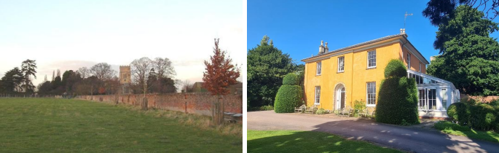
The small conservation area includes the grounds and parklands of the 19th century Langar Hall, with its stuccoed walls and views out across parkland to the west and down the Lime Avenue southward towards Cropwell Road.
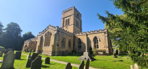
Within its grounds is the splendid and stately Grade I listed, cruciform 13th century Church of St Andrew - sometimes referred to as "The Cathedral of the Vale". Within the churchyard are three groups of Listed headstones and one tomb, marking 38 graves in total and dating from 1713 to 1816.Other notable Grade II Listed Buildings are the school and schoolhouse, dated 1842, the Unicorn’s Head public house of 1717. Langar House, set in grounds behind high walls and ornamental iron gates is Grade II* (two star) and was
the former Rectory of the Reverend Thomas Butler and birthplace of novelist Samuel Butler, author of 'Erewhon' and 'The Way of All Flesh'.
Conservation Area Boundary covers 29.16 hectares (approximate)
Number of Grade I listed buildings - 1
Number of Grade II* listed buildings - 1
Number of Grade II listed buildings - 19
A full list of Langar Conservation Area’s Listed buildings can be found in Appendix 1
Details accurate as of February 2023
3 Historical Contexts
3.1 Historical Overview
Langar is derived from the Old English, lang gara, the long gore or triangular piece of land. The likely origin of this name is the area of land in the west of the parish between the River Smite and the Stroom Dyke, which is in the form of an extended triangle. A feature shown on a LIDAR image of Langar is thought to be the site of the Anglo-Saxon manor and the later early medieval manor.
The Domesday Book of 1086 records the manor as being Langare and held by one of William the Conqueror’s key supporters, William Peverel. The manor formed part of his barony known as the Honour of Peverel. The Peverel family continued as Lords of the Manor until their estates were confiscated in 1155 by King Henry II.
Langar remained a royal possession until granted to Gerard de Rodes by Richard I with confirmation of this by King John in 1201. King John stayed at Langar for two days at Christmas 1216 to seize control of Belvoir castle, which was being held against him by William d'Aubigny's son and others on behalf of the rebel barons and the invading French army.
3.2 Location and Historic Activities
A manor house was built on the site of the current Langar Hall during the 13th century by the de Rodes which included a deer park of 20 acres. The manor was transferred to the Tibetots by John de Rodes in August 1289.
The first Tibetot was Robert who held many roles under Edward I, including Constable of Nottingham Castle. Robert died in 1298 and was succeeded by his son, Pagan, who would die at the Battle of Bannockburn in 1314. With Pagan’s death the manor fell into disrepair and in 1373 it came into the ownership of the Scrope family through the marriage of Margaret Tibetot to Richard le Scrope.
Langar was very much a minor addition to the Scrope estates, their wealth being derived from Yorkshire estates, including Bolton Castle in Wensleydale, rich in coal and lead deposits. Richard carried out a significant restoration of the manor house. As a result of its decorative castellations around the roof it became known as “Langar Castle”.
In 1654 and Langar Hall and the Manors of Langar and Barnstone became the property of the Howes of Gloucestershire. Under the Howes’, Langar Hall and Langar village would undergo major changes during the next 75 years as they established their new country seat.
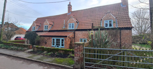
The Howes initially added land to their estate by buying up other properties from the existing owners. They also enclosed the open fields despite the objections of the Rector, Henry Mugg. To support the building programme, they established a brickyard near the Stroom Dyke. Properties built or rebuilt in this period included Church Farm, Bottom House Farm, The Unicorn’s Head, the Rectory and the medieval manor was transformed into a Palladian style house.
Extensive groundworks included the levelling of the land to the west of the hall to create a formal garden including an unusual octagonal crown bowling green, a formal garden facing the Cropwell Road and extensive water features most notably the Dutch style canals in the land below the hall. So proud were they of their achievements, the Howes advertised open-house days in the local and national press. The grounds were also used to entertain potential voters during the Howe campaigns to become the Member of Parliament for Nottingham.
Such investment could not continue, debts mounted, and the Howe finances were depleted causing Emmanuel, the 2nd Viscount Howe, to seek a source of income. From 1735 onwards the Howe family used Langar Hall sparingly as their lives took them elsewhere.
In 1814 the Nottinghamshire estates were put up for sale with those in Langar and Barnstone being bought in 1818 by John Wright, of Lenton. There is no evidence that he or any of his family ever lived at Langar Hall, which by this time was in a poor condition and was eventually demolished to be replaced by the current building in 1837. This building occupies the footprint of the east wing of the old hall and was occupied by the Marriott family who farmed the fields around the hall in addition to being keen and successful breeders of
racehorses.
The Wrights tried to sell Langar Hall on numerous occasions with no success. After the tenants vacated the hall, it was used as an engineering school by Charles Montford until 1893. In 1899 the hall and other properties in Langar were bought by Annie Bayley, the wife of Thomas Bayley, Member of Parliament for Chesterfield and remains in ownership of her descendants.
During World War One the hall and grounds were used by patients of the Bayley Red Cross Hospital, Nottingham, for recuperation from their wounds. In 1918 these were replaced by Austria-Hungarian soldiers when the hall became a prisoner of war camp. On the return of peace, the hall became a family home until it became a hotel and restaurant under the ownership of Annie Bayley’s great granddaughter, Imogen Skirving.
Other major changes took place during the period of Wright ownership in other parts of Langar. Newlands Farm was created out of the fields of the original Hall Farm and farm buildings built in 1841.The school was opened in 1842 on a site donated by the Wrights described as formerly part of the brickyard garden and premises lately occupied by John Wright, having been built with bricks sourced from demolished buildings in the hall grounds. St Andrew’s was largely demolished to the foundations of most of the outer walls, retaining some earlier features including the arcades and roof timbers, and rebuilt by rector, Thomas Butler, in the 1860’s.
In the 20th century the parish losses of World War One were commemorated by the erection of the war memorial and the enlargement of the churchyard.
The construction of Langar Airfield in World War Two resulted in the demolition of Home Farm and the loss of a number of Glebe Fields.
The need for social housing was recognised in 1937 but it took until 1948 for Bingham Rural District Council to build 12 council houses which now form Earl Howe Crescent. Despite land being offered by landowners in Langar and Barnstone the council compulsory purchased land on William Howarth’s Chestnut Farm, which resulted in him having to give up his dairy.
Disused buildings associated with Langar Airfield were used by displaced persons in the years after the war. Langar Rectory was sold by the Church Commissioners in the 1950’s and was renamed Langar House.
The village pond and allotments were turned into the front car park of The Unicorn’s Head in the 1960’s leaving a small area forming a green.
Langar School was sold in 2009 and is now a private residence. All teaching is now carried out on the site on Barnstone Road. The buildings are of CLASP design dating from 1977 but were refurbished and enlarged in 2008.
In 2015 The Unicorn’s Head was severely damaged by fire and underwent a major restoration.
3.3 Archaeology
The major archaeological sites lie outside the conservation area. The site on Hall Farm identified as St Ethelburga’s church has evidence of Iron Age, Romano-British and Anglo-Saxon occupation prior to the building of a church, which became a pilgrimage site in the medieval period. There are no surface remains visible.
Aerial photographs and LIDAR images point to significant activity in the fields west of Langar Hall, but these remain to be identified. The recently identified medieval deer park was to the North of the present water feature of Langar Hall.
Within the conservation area aerial photos show the outlines of garden features between the bowling green and the lawn in front of Langar Hall and what may be signs of early occupation in the field between Langar Hall and the Cropwell Road. There are also outlines of buildings in the field south of Church Farm and the field to the west of Unicorn Lodge. As they do not appear on the Township Map or later Ordnance Survey maps, they must date to earlier than 1818.
Some medieval and early modern features survive the reconstruction of St Andrew’s. These include the Main Door, the tombs in the North and South Transept, grave slabs in the South Transept and medieval graffiti on a number of the aisle pillars.
3.4 Historic Plan, Form and Layout
The pre-conquest form of the village was one of dispersed dwellings and small farms with the Manor House located in an area of land to the west of the current village between the River Smite and the Stroom Dyke.
During the medieval period a new manor house was built on the site of the current Langar Hall Hotel and the village was located in its present position near St Andrew’s Church consisting of a collection of crofts and tofts surrounded by open fields divided up into strips.
There are substantial remains of the ridge and furrow of these strips within the parish, most notably off Langar Lane. Enclosure of these is recorded from the 17th century onwards and was complete by the mid-18th century. Contemporary with the enclosure, the existing Limes Farm and Bottom House Farm were developed, and the buildings remodelled, and Church Farm and Chestnut Farm were built.
The present road layout is largely the result of developments carried out by the Howe family in developing Langar as its main country seat between 1675 and 1735.
The original main road to Nottingham followed a route from the present Langar Crossroads westward parallel with Barnstone Road and Church Lane passing to the south of the church and joining the present road 50 metres to the east of the entrance to Langar Hall Hotel.
Documents relating to the building of the 18th century Rectory (Langar House) record the realignment of the route to that of Barnstone Road and make mention of the “former road to Nottingham”. It is likely that Main Street was created as a result of moving the Nottingham route away from the hall as part of the emparkment of the land to the south of the church and hall.
Musters Road was opened in the 1970’s as a continuation of Harby Lane to the Barnstone Road with the creation of a crossroads. Willow Lane, Butler’s Field, Belvoir Crescent and Earl Howe Crescent are all of 20th century date.
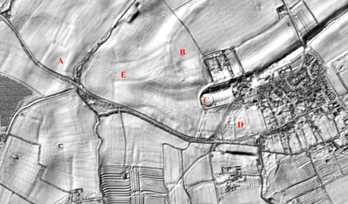
A is the site of the pre-conquest manor,
B is the deer park of the medieval manor,
C is an 18th century bowling green in the pleasure gardens of Langar Hall,
D is the route of the original road to Nottingham and
E are possible pre-Roman field boundaries.
The remains of the ridge and furrow of the medieval open fields can be seen in the centre bottom (see Figure 2). The outlines of the “croft and tofts” of the medieval village can be seen below the line of Cropwell Road on the mid to lower right.
3.5 Historical Mapping
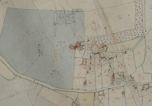
A detail from the Map of the Townships of Langar and Barnstone produced in 1818 as a result of the sale of the Langar and Barnstone’s estates by the Howes to the Wright’s.
At some stage between 1818 and 1842 new buildings were added in red by an unknown hand.
The present Langar Hall is shown as occupying the footprint of the East Wing of the demolished medieval hall. A number of buildings are shown which no longer exist including the stable block of Langar Hall, which is the rectangular building with an inner courtyard. It stood on the lower part of Church Green and under the current barn.
It is to be noted how few residential buildings are present with fields and enclosures occupying most of the area occupied by housing in 2023.
There is little sign of development of the village other than the new schoolhouse on Church Lane built in 1842 and Hill Farm near the present-day crossroads. The line of the present-day Musters Road is shown as a footpath.
4 Spatial Analysis
The relationship between open spaces and the built form within a conservation area can be central to its character. This section describes the village’s layout, highlighting the significant views, landmarks and historical focal points. The contribution of open green spaces, trees and other natural elements to the conservation area’s character is also described within this section.
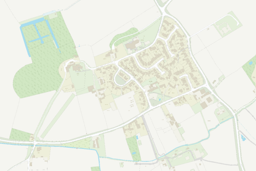
4.1 Current Plan, Form and Layout
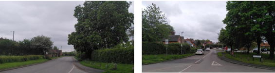
Langar has a simple layout of four principal roads. The first of these is Cropwell Road which runs roughly east-west along the south of the main built-up area of the village.
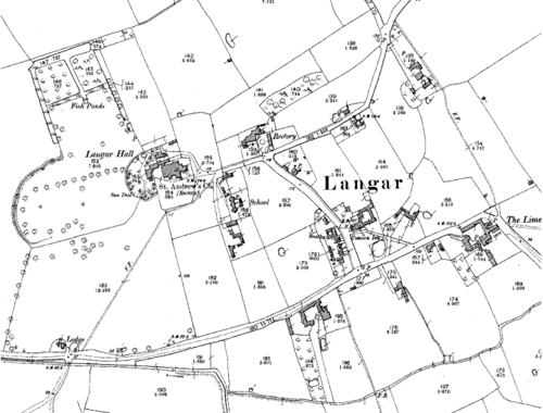
On the southern side of the road are a number of farmhouses with their associated agricultural buildings. At its eastern end, Cropwell Road forms a T junction with Musters Road, which effectively forms the eastern boundary of the village. Access to the centre of the village is via Main Street which heads northwards from Cropwell Road and then turns westwards into Church Lane (see Figure 5 and Figure 6).
The majority of the housing in Langar, which is mostly modern and detached, is concentrated to the west of Main Street with older properties situated along Cropwell Road, Main Street and Church Lane. Church Lane itself leads to an open area around Langar Primary School, St Andrew’s Church and the rear access to Langar Hall.
Finally, running south westwards from the Hall is a drive lined with Lime trees which meets Cropwell Road at the village’s westernmost extent. Most of the buildings in the village have their principal elevations fronting the highway but some are set in their own grounds and face onto private gardens.
Below is a map that further describes the current plan, form and layout of the village/town.
This map is reproduced from Ordnance Survey material with the permission of Ordnance Survey on behalf of the Controller of His Majesty’s Stationary Office © Crown Copyright. Unauthorised reproduction infringes Crown Copyright and may lead to prosecution or civil proceedings.
Rushcliffe Borough Council - 100019419
4.2 Landmarks, Focal Points and Views
Langar Hall and St Andrew’s Church are the village’s most significant landmarks and are visible in views from Cropwell Road and Church Lane.
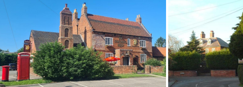
The Unicorn’s Head Public House and Langar House also feature heavily in the street scene with the former being in a prominent position at the entrance to the village and the latter closing the view northwards along Main Street.
The open nature of the Conservation Area and the limited number of buildings affords good views of the surrounding countryside and parkland. One of the finest views looks northwards from the grounds of Langar Hall to Wiverton Hall (approximately 1½ miles away) which stands out as a feature in the landscape.
The Townscape Appraisal map in Appendix 2 illustrates these key views and other views which link the village to the adjacent countryside.
4.3 Open Spaces, Trees and Landscape
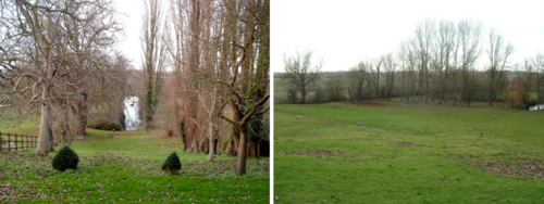
The Langar Conservation Area incorporates large areas of open space between buildings with the parkland of Langar Hall and the churchyard of St Andrew’s providing some of the most attractive open spaces.
The green at the Main Street/Cropwell Road junction is also significant in the street scene. It frames views towards the Unicorn’s Head pub and includes a pocket nature reserve created in 2011 on the site of a historic village pond.
Around the agricultural buildings to the south of Cropwell Road there are a number of hedge lined paddocks and small fields which contribute positively to views south of the village.
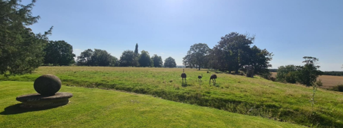
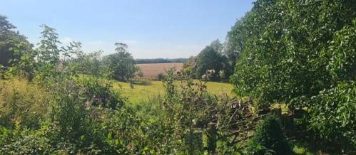
Hedgerows and grass verges can also be found lining the approaches to the village. An iron park rail fencing, and groups of mature trees are a particular feature of the parkland around Langar Hall.
The gate piers and wall at Langar Hall's southern enclosure, (south of Hall, between the Church and Cropwell Road) was built in the between the 17th and 18th Century, is noteworthy. The low walls are made of brick with half-round stone coping. In the centre of the northern side the walls rise up to the square, rusticated, ashlar gate piers which each have 2 moulded cornices and an ornamental finial. The gateway itself has been bricked up. It is worth noting that the wall does not extend along the southern side of the enclosure adjacent to the road.
Areas of open green space which make a positive contribution to the character of the Conservation Area are shown in Appendix 2 - Conservation Area Boundary and Townscape Appraisal Map.
4.3.1 Open Spaces, Trees and Landscape SWOT Analysis
Strengths - what are the positives of the open spaces, trees, and landscape
- There is plenty of open space, and we are surrounded by grassland, established trees and plants.
Weaknesses - what are the negatives of the open spaces, trees, and landscape
- Monoculture doesn’t reflect the flora and fauna of the area. It does not generate wildlife.
- There are plenty of wildflowers. Mowing wildflower site at the crossroads spoils the appearance.
- Work to improve the pond is ongoing.
Opportunities – what could make the open spaces, trees, and landscape better?
- Pressure for housing Brownfield site for Fletcher’s Yard, not greenfield Developments for greener energy, including solar panels, heat pumps / other greener heating and electric vehicle charging may have visual impact or extra costs to mitigate.
Threats - what would make open spaces, trees and landscapes worse?
- Pressure for housing Brownfield site for Fletcher’s Yard, not greenfield
- Developments for greener energy, including solar panels, heat pumps / other greener heating and electric vehicle charging may have visual impact or extra costs to mitigate.
Works to Trees
You must contact the Local Planning Authority (LPA), Rushcliffe Borough Council before any works (cutting OR pruning) are carried out to trees within the Wiverton Conservation Area.
Six weeks’ notice is required before any works to trees within the Conservation Area is carried out, even if they are not protected by a Tree Preservation Order (TPO).
If there is a tree which undergoes annual maintenance, include this information with the notice. It may be possible, upon agreement with the tree officer, that only one notice is required to cover the future annual maintenance.
Standard notification forms (a section 211 notice), further information and contact details.
A flow chart of the decision-making process regarding works to trees.
4.4 Public Realm
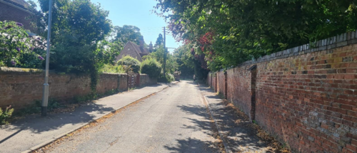
The highways and pavements in Langar are all surfaced with asphalt but the frequent use of hedgerows, tree lines and grass verges as boundary treatments maintains the rural character of the village. Other boundary treatments include brick walls of varying heights (which are even used as a field boundary in one instance), metal fences and timber fences.

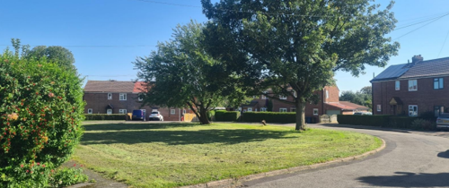
While the public area around Earl Howe Crescent may not boast notable architectural features (see Figure 18 on page 16), the arrangement of the dwellings create the semi-circular green which exemplifies the council's approach to public housing during that era. This ensemble creates a distinctive character to the western side of Main Street, with this public space at its centre.
5 Buildings of the Conservation Area and Key Characteristics
5.1 Building Types and Activity
The older buildings in Langar consist of a mixture of small cottages, two country houses (Langar Hall and Langar House), 17th and 18th century farmhouses with their associated ranges of outbuildings, an 18th century coaching Inn with brewhouse and stables (The Unicorn’s Head), a Victorian school building and a 13th century cruciform church (St Andrew’s). Many of these can be seen on the historical maps shown in section 3. More modern structures within the Conservation Area include a handful of 20th century houses, and a variety of agricultural buildings.
5.1.1 Building types and Activity SWOT Analysis
Strengths - what activities/places can you go that make the village/town great?
- Very impressive buildings, including the church, grade 1 listed building dating from 12th century with enhancements over the years, especially in Victorian times.
- In addition, 17th century pub, Bottom House Farm, the Limes, traditional brick and 18th century development.
Weaknesses - what activities/places exist that detract from making the village/town great?
- People on the periphery of the conservation area can do what they like and erect modern buildings.
Opportunities - what activities/places could exist that would village/town even better?
- The number of parked vehicles on pavements could be reduced enhance accessibility and visibility.
Threats - what activities/places would make village/town worse?
- The ongoing challenge of a lack of funding for maintenance, time passing and the consequent neglect. The outcome of which is evidenced in two parts of the church wall collapsing.
5.2 Key Characteristics and Building Materials
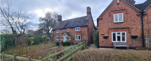
Pre-19th century unlisted dwellings tend to have single storey elevations with dormer windows. The effect, for instance on Church Green at the junction of Main Street and Cropwell Road, is relatively modest, homogeneous and in scale with brick agricultural buildings of the time on Cropwell Road (some of which have been sympathetically converted to dwellings).
Many later Victorian and modern dwellings are two-storey with the exception of 20th century bungalows and barn conversions.
Roofs are dominated by orange clay pantiles and plain tiles with a few examples of Welsh slate. Gable ends are plain close verge, where the tiles run to the edge of the brick gables, or have parapets. Brick chimneys in a variety of styles, sizes and positions are prominent roofline features on many of Langar’s buildings.
Pitched roof dormers and decorative chimneys are a common feature.
In addition to the general characteristics of the Langar Conservation Area, below details more characteristics particular to a character zone.
5.2.1 Key Characteristics: St Andrew’s Church and Church Lane - Zone 1
Materials:
Walls: 13th century coursed and squared ironstone walls with limestone dressing to the Church (heavily restored in 1860s).
Elsewhere, is red brick in various bonds.
Windows: The Church has perpendicular Gothic windows to the chancel, early English Gothic lancet and triple lancet windows.
Elsewhere in this character zone windows are mainly timber framed.
Key Characteristics / Architectural Features:
13th century, Grade I listed Church. Cruciform plan, with north and south aisles, square porch and square crossing tower.
All of the parapets have regularly spaced crenels and merlons to form the embattlements which significantly contributes to the church’s character.
St Andrews churchyard encircled by brick wall with stone coping.
Numerous listed gravestones and tombs.
Grade II Langar Church of England Junior School buildings (see Figure 22), cottages and farmhouse.
Early 18th century Grade II Langar House set in private grounds behind high brick walls.
Informal planting of small trees and shrubs. Langar Hall Staff car park.
5.2.2 Key Characteristics: Langar Hall and Parkland – Zone 2
Materials:
Walls: Ochre coloured render to exterior walls of Hall and Lodge.
Roofs: There is a mix between orange clay pantiles and Welsh slate within this character area.
Key Characteristics / Architectural Features:
Grade II listed Langar Hall (see Figure 10) set within gardens, pastureland and paddocks which contributes to the openness of the area. This openness is key to its the characteristic.
Hedgerows and grass verges line Cropwell Road. Groups of mature trees including a Lime tree avenue along gravel drive to Langar Hall. Metal fences and a brick wall are the predominant manmade boundaries
5.2.3 Key Characteristics: Village Centre – Zone 3
Materials:
Walls: Orange/red brick with some buildings having decorative string courses, ashlar details and blue brick accents.
Roofs: Dominated by orange clay pantiles and plain tiles with a few examples of Welsh slate. Gable ends are plain close verge, where the tiles run to the edge of the brick gables, or have parapets.
Windows: A variety of window types including Georgian timber sliding sashes, timber casements in a variety of configurations and some ashlar mullioned casements.
Doors: Painted or varnished timber in a wide variety of styles including part glazed, plank and batten and panelled.
Key Characteristics / Architectural Features:
Dominated by 18th century Unicorn’s Head Public House (see Figure 11 and Figure 20), small village green and pub car park.
This character area also has a row of traditional cottages along Main Street and 20th century housing development on Earl Howe Crescent.
Earl Howe Crescent was built as a public housing scheme by Bingham Rural district Council in 1948, along with two semi-detached houses on Church Lane. All are now privately owned. Whilst not of particular architectural merit, the dwellings, and their arrangement around a semi-circular green, constitute a good example of council housing of that era and form an ensemble which adds distinctive
character to the west of Main Street.
5.2.4 Key haracteristics: Farmhouses and Agricultural Buildings set among small fields and paddocks – Zone 4
Materials:
Walls: Walls: Pre 20th century agricultural and former agricultural buildings are brick in various bonds. Modern agricultural buildings utilise a portal frame and lighter cladding materials.
Roofs: Dominated by orange clay pantiles and plain tiles. The roofs of the modern agricultural buildings vary, but where visible from the public domain are a dark grey in appearance.
Key Characteristics / Architectural Features:
Farmhouses and agricultural buildings are characteristic of this area. All are set among small fields and paddocks which offer views out into the countryside.
Many older agricultural buildings have been converted in to residential, however modern agricultural buildings are still in operation.
The stream, hedgerows, and trees to the south forms the border to this character area. Hedgerows and grass verges for the border along Cropwell Road and Musters Road and contribute to the character of the area.
5.3 Character Zone Map
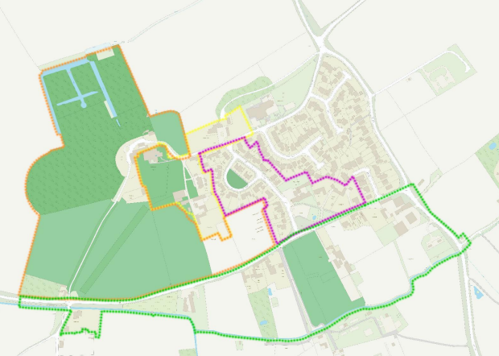
Zone 1 - St Andrew’s Church and Church Lane (yellow boundary)
Zone 2 - Langar Hall and Parkland (orange boundary)
Zone 3 - Village Centre (purple boundary)
Zone 4 - Farmhouses and Agricultural Buildings set among small fields and paddocks (green boundary)
5.3.1 Key Characteristics SWOT Analysis
Strengths:
Classic buildings.
Bricks made in the village and used in the houses.
Living history.
Weaknesses:
Maintenance of buildings is expensive. Wooden frames on windows are expensive.
Opportunities:
New builds could be built from equivalent materials and use recycled materials.
There’s an opportunity for earth to be used as a construction material, this aesthetic would be welcome
Threats:
New builds out of keeping with the village.
Dereliction of existing buildings.
5.4 Listed buildings
Buildings on the Government’s List of Buildings of Special Architectural or Historic Interest are called “Listed” buildings and are protected by law. Consent is required from Rushcliffe Borough Council before any works of alteration, extension, or demolition can be carried out on any listed building.
Further information can be found in Rushcliffe Borough Council’s publication Listed Buildings in Rushcliffe.
The complete up-to-date list of the Secretary of State’s Statutory List of Buildings of Special Architectural Interest or Historic Interest.
In addition to St Andrews Church (see Figure 8 on page 11), Langar Hall (see Figure 10 on page 11) and Langar House (see Figure 12 on page 12), the following are also listed buildings.
Names of the Listed Buildings and structures in Langar Conservation Area (correct as of 2023) are detailed in Appendix 1. All Listed Buildings are shown on the Townscape Appraisal plan, but some smaller structures such as gravestones may not be shown.
Range of cottages now one dwelling. Early 18th century, altered. Brick. Steeply pitched pantile roof. Single storey with attics. 4 bays. Central, later brick lean-to porch.
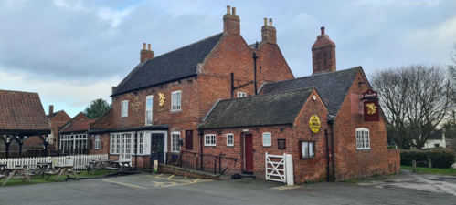
Public House Grade II Listed. Dated 1717. Brick. Twin, plain-tile roofs, steeply pitched with coped gables on square kneelers and end stacks. Two storeys. Double depth plan.
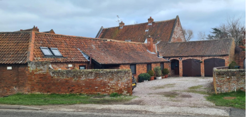
Former stable range including garage to north (formerly listed as stables) now a house. Grade II listed. Likely 18th century, part-rebuilt and converted in the 1980s. Brick. Steeply pitched pantile roof with dentil eaves cornice and one ridge stack. Lean to addition at the rear as shown in the image.
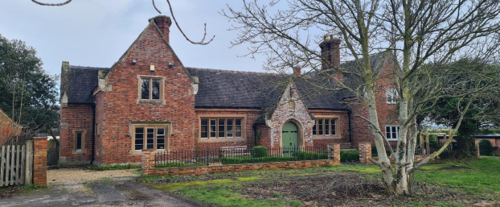
Former Langar School (Church of England) and School House. Grade II listed. Dated 1842. Brick in Flemish bond with ashlar dressings. Steeply pitched slate roof with moulded-brickwork eaves cornice and ashlar gable-copings on large moulded and gabled ashlar kneelers. Two, symmetrically placed ornamental stacks with grouped octagonal flues. Tudor style.
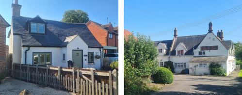
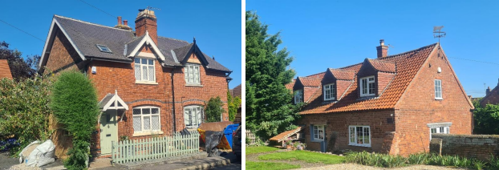
5.5 Key Unlisted Buildings
Contribution to the established character of the place can also come from buildings which are not recognised via listing or may not be old.
In addition to the buildings identified within Section 5.2, the following has also been identified as a key unlisted building. A plan with all of the positive contributions to the area can be found in Appendix 2 - Conservation Area Boundary and Townscape Appraisal Map.
6 Generic Management Plan for Conservation Areas in Rushcliffe
6.1 Introduction
In carrying out its planning functions, the Borough Council is required in law to give special attention to the desirability of preserving or enhancing the character or appearance of Conservation Areas. The Management Plan for a Conservation Area is a tool to ensure the special character of the area is preserved and enhanced. The management plans aim to:
- Outline a strategic management proposal for the preservation and enhancement of the Langar Conservation Area.
- Act as a guide for professionals and residents alike regarding:
- features of value, worthy of preservation;
- characteristics worthy of preservation;
- opportunities for enhancement;
- development proposals which preserve and enhance the special character of the area.
- Inspire community commitment to conservation principles and reporting.
6.2 National and Local Policies and Guidance
There is a duty to formulate and publish management plans setting out policies and proposals for the preservation and enhancement of Conservation Areas. Many of these policies and proposals are common to all Conservation Areas, and these are set out in this document. The Central Government Guidance and Local policies applicable to Conservation Areas include:
- Rushcliffe Local Plan Part 1: Core Strategy, with a specific focus on:
- Design and Enhancing Local Identity [in part]
- Historic Environment
- Rushcliffe Local Plan Part 2: Development Policies, with a specific focus on:
- Conserving and Enhancing Heritage Assets
- Development Affecting Archaeological Sites
- The National Planning Policy Framework (NPPF), particularly, but not exclusively the chapter on Conserving and Enhancing the Historic Environment.
- The National Planning Practice Guidance (NPPG) (updated 2021 and subject to continual review)
- By Design: Urban Design in the Planning System – Towards Better Practice (2000)
- The Planning (Listed Buildings and Conservation Areas) Act 1990
- Historic England “Historic England Advice Note 1: Conservation Area Designation, Appraisal and Management”
The council will utilise the full range of strategic policy and guidance documents to ensure that development in Langar Conservation Area is of a standard that enhances the amenity of the local area. The council will always look to use the most up-to-date versions of the document.
Supplementary documents may be issued for individual Conservation Areas where specific policies or proposals are needed.
6.3 Article 4 Directions
There are extra consents required in Conservations Areas. For example, in addition to the general control of development, you will
need to get permission for
- Any additions or alterations to the roof (for example, dormer windows)
- The installation of satellite dishes on chimneys, roofs or walls fronting a highway
- Any extension which extends beyond the side of the original dwelling house
- Any extension of more than one storey that extends beyond the rear wall of the original dwelling house
- Cladding the exterior of the dwelling
- Any demolishing of a building or part of a building that has a volume over 115 cubic metres
Article 4 of the Town and Country Planning (General Permitted Development) Order 1995, allows planning authorities to restrict
some permitted development rights within particular areas. This does not necessarily prevent development or change taking place
but enables the Local Authority to manage the design and detailing of the works, and potentially grant permission subject to appropriate conditions. The use of Article 4 Directions will be proposed where it is considered appropriate following the completion of each Area Appraisal across the Borough.
Details of Article 4 Directions for Langar Conservation Area
There are currently no Article 4 Directions for Langar Conservation Area.
6.4 Building Design
Mimicking the local vernacular is not the only way to ‘fit in’ with the character of a conservation area. National policy makes clear that contemporary designed, provided it is sympathetically designed, cannot be dismissed as an option. Therefore, good contemporary design will be encouraged where it respects the context’s character, scale and massing. This must be demonstrated in the Design and Access Statement submitted with any planning application.
Extensions to buildings in Conservation Areas should respect:
- The key characteristics of the original building, including scale, mass, materials and proportions
- The contextual setting and character of the Conservation Area
Copying like for like can devalue and destroy the ability to “read” historic change, and dilutes our historic heritage. Pastiche designs, incorporating poor imitations of other styles, will be resisted, particularly where they incorporate details which are not locally appropriate. Careful high-quality replication may be required in a few very sensitive locations.
In particularly sensitive locations, such as uniform terraces, exact replication may be necessary to maintain compositional unity. In that case, attention to details, choice of materials and high-quality workmanship are the keynotes. However, in some cases, a direct relationship is not impossible. For example, Flemish Bond brickwork cannot be replicated in cavity walls, and narrow lime mortar joints cannot be replicated in modern metric brickwork.
Where a new building is appropriate, on infill sites or where an existing building detracts from the character of the area, the opportunity should be taken to re-establish the streetscape, reinforce enclosure, open up distant vistas or views of landmarks or hide unsightly views.
“New and old buildings can coexist happily without disguising one as the other, if the design of the new is a response to urban design objectives” (DETR – “By Design”, p19).
As with extensions, good contemporary design which respects local character, and the context of the site will be encouraged.
All new buildings should respond appropriately to the existing frontage and normally follow the established building line. Development or redevelopment will normally be resisted if:
“it blocks important views identified in the individual appraisals, uses important open spaces identified in the appraisals, adversely affects the setting of any Listed or key buildings, fails to maintain or re-establish the streetscape where appropriate dominates its Conservation Area background fails to recognise the context of
the site destroys important features identified in the individual appraisals such as boundary walls, fences,
hedgerows or trees”
Where the quantity of contemporary schemes in a small area becomes significant and outnumbers older buildings within the area, further contemporary schemes could fundamentally shift the architectural character of the area and thus be harmful, even if well designed as an individual project.
New development that stands out from the background of buildings may be appropriate in exceptional circumstances if it contributes positively as a landmark to enhance the street scene, to highlight a corner or to signal a visual change of direction such as along a curving vista.
Any external lighting should be carefully designed and sited to minimise light pollution.
Energy producing or saving devices are generally welcomed by the Council, but careful consideration is required when these are to be located in a Conservation Area and some may require planning permission. In particular, they should be positioned to minimise their impact on the building and on the local amenity.
6.5 Publicity and Knowledge Transfer
Ambiguity about additional controls within a Conservation Area raises the likelihood of inappropriate developments occurring which
may damage the integrity of the conservation area designations.
Efforts have been made to engage local community groups in the development and review of the character appraisals. Empowering
communities to define the special architectural and historic interest of the Conservation Area aims to raise awareness.
Whether the appraisal took a community-led or a council-led approach, upon reviewing all Conservation Areas, the public were invited to ask questions and comment during a public consultation.
A consultation event also aimed to diminish any ambiguity about restrictions within a Conservation Area and increase the likelihood of sensitive and appropriate developments, maintaining the character of the area.
The council recognise the potential issues of turnover in residency and ownership of properties in the conservation area. Therefore,
Rushcliffe Borough Council will periodically use their media outlets to highlight conservation area designations and the significant,
related planning controls.
The approach taken within Langar Conservation Area was Community Led
The consultation period took place between the following dates 19/01/2024 and 13/03/2024
The date of the Consultation Event 03/02/2024
If there are any queries about conservation areas, please email conservationareas@rushcliffe.gov.uk
6.6 Public Realm
General maintenance and upkeep to the public realm may include fixing damage to roads and pavements, and fixing issues with street lighting. Issues such as these can impact the quality of the Conservation Area.
The council aims to encourage works to the public realm that are in keeping with, or actively enhance the conservation area. Rushcliffe Borough Council can only advise on work within the public realm that does not require planning permission (for example work completed by statutory undertakers, such as the Highways Authority). In these instances, Rushcliffe borough council cannot prevent such work.
Nottinghamshire County Council are responsible for repairs to roads, pavements and street lighting. Report issues of repairs to roads, pavements and street lighting to Nottinghamshire County Council online.
Rushcliffe Borough Council will continue to undertake their duties in maintaining the public realm. Vandalism, fly tipping and street cleaning are all the responsibility of Rushcliffe Borough Council. Report issues to Rushcliffe Borough Council online.
You must contact the Local Planning Authority (LPA), Rushcliffe Borough Council, before any works (cutting OR pruning) are carried out to trees within the Langar Conservation Area
Six weeks’ notice is required before any works to trees within the Conservation Area is carried out, even if they are not protected by Tree Preservation Order (TPO).
Standard notification forms (a section 211 notice) - further information and contact details.
A flow chart of the decision-making process regarding works to trees.
6.7 Boundary Treatments
Where there is a proposal for a new boundary treatment to be installed, the council would encourage the use of boundary treatments within the area.
Within conservation areas, planning permission is required to alter, maintain, improve, take down or build any new gate, fence, wall or other enclosure with:
- A height of one metre or more if next to a highway (including a public footpath or bridleway), waterway or open space; or
- A height of two metres or more elsewhere.
Where planning permission is required to remove a wall, Rushcliffe Borough Council will aim to protect those boundary walls and fences that have been identified as positively contributing to the area.
Hedgerows are significant habitats for wildlife in lowland Britain. Regulations are intended to protect important hedges in the countryside. The policy applies to hedges that are more than 20m long, (or less if connected to another hedge) on or adjacent to:
- Land used for agriculture or forestry, including the keeping of horses or donkeys
- Registered common land and village greens
- Local Nature Reserves and Sites of Special Scientific Interest.
The policy does not apply if the hedge is within or on the boundary of the curtilage of a house.
6.8 Buildings at risk
A few of the important buildings across the various Conservation Areas are currently vacant or not in regular use, which may lead to some being “at risk” of neglect or decay.
The Council will encourage and advise on renovation and repair work that is sensitive to the original or traditional historic character of the building and retains original features. The council will monitor the opportunity and potential for grant aid schemes to encourage the basic maintenance work necessary to ensure that key buildings within the conservation area are structurally sound and weather tight. However, given the current financial climate and outlook, such schemes are unlikely in the short to medium term.
There is a presumption against the demolition of buildings which contribute to the character of the area unless there are exceptional circumstances. It would benefit both the physical form and the function of the Conservation Area if these buildings were repaired, maintained and brought back into use.
Where the poor condition of a building or structure is as a result of neglect and lack of maintenance by its owner there is no requirement for the Borough Council to take its deteriorated condition into account when deciding whether demolition is appropriate. This is to avoid rewarding the deliberate neglect of buildings by representing such action as a way to obtain planning permission for demolition and redevelopment.
6.9 Enforcement
Rushcliffe Borough Council will, from time to time, assess and monitor changes in the appearance and condition of Langar Conservation Area. This will ensure that where necessary enforcement action can be taken promptly to deal with problems as they arise.
Where co-operation cannot be gained by any other means, Rushcliffe Borough Council has the ability to use additional enforcement powers to tackle particular issues within conservation areas. The Council may take formal action if the condition of any building (listed or unlisted) which makes a positive contribution to the character of the Conservation Area is considered to be at risk.
The council will work in accordance with their enforcement policy, which aims to provide an efficient enforcement service in support of the Council’s statutory planning service. Rushcliffe Borough Council’s enforcement actions will remain transparent, consistent, and proportionate, as it is recognised that effective controls over unauthorised development assists in conserving the natural and built environment whilst helping to protect the quality of people’s lives and maintaining the Council’s integrity.
7 Appendix 1 – Listed Buildings (as of January 2023)
Grade: II*
Listing entry number: 1235998
National grid reference: SK 72259 34714
Location: Langar House, Church Lane, NG13 9HG
Garden Boundary Walls to West and South of Langar House Including Gateway to West
Grade: II
Listing entry number: 1236005
National grid reference: SK 72241 34718
Location: Garden Boundary Walls to West and South of Langar House Including Gateway to West, Church Lane
Grade: II
Listing entry number: 1235965
National grid reference: SK 72210 34649
Location: Church Cottage, Church Lane
Langar Hall Including East West Range Adjoining and To Northeast
Grade: II
Listing entry number: 1236012
National grid reference: SK 72090 34653
Location: Langar Hall Including East West Range Adjoining and To Northeast, Church Lane
Gateway And Walls to Enclosure South of Langar Hall Between Churchyard and Cropwell Bishop Road
Grade: II
Listing entry number: 1236125
National grid reference: SK 72168 34560
Location: Gateway And Walls to Enclosure South of Langar Hall Between Churchyard and Cropwell Bishop Road, Church Lane
Gate piers To Entrance Drive of Langar Hall
Grade: II
Listing entry number: 1264805
National grid reference: SK 72142 34675
Location: Gate piers To Entrance Drive of Langar Hall, Church Lane
Langar School (Church of England), School House
Grade: II
Listing entry number: 1235969
National grid reference: SK 72222 34594
Location: Langar School (Church of England), Church Lane
Former Stable Range Immediately North of Bottom House Farmhouse Including Garage to North
Grade: II
Listing entry number: 1236626
National grid reference: SK 71304 36396
Location: Former Stable Range Immediately North of Bottom House Farmhouse Including Garage to North, Cropwell Bishop Road
Former Cattlesheds Along North Side of Farmyard at Bottom House Farm
Grade: II
Listing entry number: 1235974
National grid reference: SK 72335 34441
Location: Former Cattlesheds Along North Side of Farmyard at Bottom House Farm, Cropwell Bishop Road
Grade: I
Listing entry number: 1264793
National grid reference: SK 72127 34652
Location: Church Of St Andrew, Church Lane
Headstones In Churchyard of Church of St Andrew in Angle of South Transept and Chancel
Grade: II
Listing entry number: 1236056
National grid reference: SK 72141 34646
Location: Headstones In Churchyard of Church of St Andrew in Angle of South Transept and Chancel, Church Lane
Headstones In Churchyard of Church of St Andrew South of Nave
Grade: II
Listing entry number: 1235967
National grid reference: SK 71304 36396
Location: Headstones In Churchyard of Church of St Andrew South of Nave, Church Lane
Churchyard Wall Along East Side of Yard
Grade: II
Listing entry number: 1235966
National grid reference: SK 72157 34650
Location: Churchyard Wall Along East Side of Yard, Church Yard
Grade: II
Listing entry number: 1236120
National grid reference: SK 72116 34630
Location: Crosland Chest Tomb in Churchyard of Church of St Andrew Approximately 5 Metres South of The West End of The Nave, Church Lane
Langar-cum-Barnstone War Memorial
Grade: II
Listing entry number: 1467423
National grid reference: SK 72145 34645
Location: Southeast Corner of Churchyard, Church of St Andrew, Church Lane, Langar, Nottinghamshire, NG13 9HG
Garden Boundary Walls to West and South of Langar House Including Gateway to West
Grade: II
Listing entry number: 1236005
National grid reference: SK 72241 34718
Location: Garden Boundary Walls to West and South of Langar House Including Gateway to West, Church Lane
Grade: II
Listing entry number: 1235970
National grid reference: SK 72589 34537
Location: The Limes Farmhouse, Cropwell Bishop Road
The Unicorns Head Public House
Grade: II
Listing entry number: 1235976
National grid reference: SK 72418 34573
Location: The Unicorns Head Public House, Main Street
Grade: II
Listing entry number: 1235971
National grid reference: SK 72364 34426
Location: Bottom House Farmhouse, Cropwell Bishop Road
Grade: II
Listing entry number: 1236626
National grid reference: SK 72336 34417
Location: Barn Court, 3, Cropwell Bishop Road
K6 Telephone Kiosk Outside the Unicorns Head
Grade: II
Listing entry number: 1264483
National grid reference: SK 72404 34556
Location: K6 Telephone Kiosk Outside the Unicorns Head, Main Street
*The titles of these listings may not make it clear that all listed buildings always include all attached structures and extensions, regardless of age, and all detached outbuildings built before 1 June 1948 which are, or were at the time of listing, ancillary to the function of the primary listed building and were in the same ownership at the time of listing.
For example, when a house is listed, the listing will apply to extensions, porches, detached historic stables, barns, wash houses, privies etc. Such outbuildings and extensions are only exempt from the provisions of listing where the listing specifically excludes them. Appendix 2 - Conservation Area Boundary and Townscape Appraisal Map.
8 Appendix 2 – Conservation Area Boundary and Townscape Appraisal Map

The Langar Townscape Map above shows:
- Locations of listed buildings
- Locations of key unlisted buildings
- Open space
- Locations of trees, hedges, and significant hedges and fences
- Viewpoints
Conservation Areas
- Bingham Conservation Area
- East Bridgford Conservation Area
- East Leake Conservation Area
- Hawksworth Conservation Area
- Hickling Conservation Area
- Ruddington Conservation Area
- Thoroton Conservation Area
- Wiverton Conservation Area
- Langar Conservation Area
- West Leake Conservation Area
- Whatton in the Vale Conservation Area
- Sutton Bonington Conservation Area
- Upper Saxondale Conservation Area
- Wysall Conservation Area