West Leake Conservation Area
West Leake Conservation Area Appraisal and Management Plan March 2023

Contents
1.1 Conservation Areas
1.2 The Purpose of a Conservation Area Character Appraisal
1.3 The Planning Policy Context
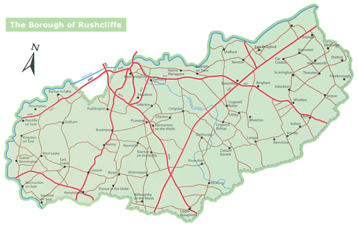
2 West Leake Location and Landscape Setting
2.1 The West Leake Conservation Area
3.1 Archaeology
3.2 Location and Historic Activities
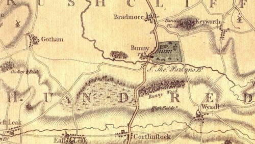
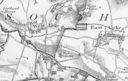
3.3 Historical Mapping
4.1 Plan, Form and Layout
4.2 Landmarks, Focal Points and Views
4.3 Open Spaces, Trees and Landscape
4.4 Public Realm
5 Buildings of the Conservation Area and Key Characteristics
5.1 Building Types and Activity
5.1.1 Building types and Activity SWOT Analysis
5.2 Key Characteristics and Building Materials
5.2.1 Key Characteristics: SWOT Analysis
5.3 Listed buildings
5.4 Key Unlisted Buildings
6.1 Introduction
6.2 National and Local Policies and Guidance
6.3 Article 4 Directions
6.4 Building Design
6.5 Publicity and Knowledge Transfer
6.6 Public Realm
6.7 Boundary Treatments
6.7.1 Walls and Fences
6.7.2 Hedges
6.8 Buildings at risk
6.9 Enforcement
7 Appendix 1 – Listed Buildings (as of March 2023)
8 Appendix 2 – Conservation Area Boundary and Townscape Appraisal Map
1 Introduction
1.1 Conservation Areas
Rushcliffe Borough Council has an obligation under Section 69 of the Planning (Listed Buildings and Conservation Areas) Act 1990 to review, from time to time, its Conservation Area designations.
A Conservation Area, as defined under Section 69, is ‘an area of special architectural or historic interest the character or appearance of which it is desirable to preserve or enhance’.
West Leake Conservation Area was originally designated in 1990. Prior to this appraisal of 2023, the most recent appraisal of the West Leake Conservation Area was carried out in 2010.
Section 71 of the Planning (Listed Buildings and Conservation Areas) Act 1990 highlights the local planning authority’s duty to formulate and publish proposals for the preservation and enhancement of the conservation areas. This document, therefore, aims to identify and
reaffirm (or redefine) the special architectural or historic interest of the area which warrants its designation.
A Conservation Area Appraisals are not, and never have been, tools for to fossilise a place against change, instead, the processes of change which allow places to grow and evolve are recognised as being unavoidable, and it is also recognised that change can be a positive and desirable force. The designation instead allows greater scrutiny and control to manage change to positive effect and to ensure that any changes which require planning permission do not harm, and ideally serve to actively enhance, the existing character of the place.
West Leake Conservation Area: Summary of Special Interest
West Leake’s strong rural tradition is evident in its many agricultural buildings and views into the open countryside.
The centre of the village is well defined and compact, with a pronounced linear plan form.
Mature native trees and hedgerows give a verdant, sylvan character to the area.
1.2 The Purpose of a Conservation Area Character Appraisal
The purpose of a Conservation Area Character Appraisal is to:
- Identify and record the special interest of the Conservation Area to ensure there is public awareness and understanding of what is
worthy of preservation. - To define and reassess current boundaries to accurately reflect what is now perceived to be of special interest.
- To identify opportunities to safeguard and enhance the special interest of the Conservation Area.
It should be noted that the content in this document is not a comprehensive account of every significant building, structure, tree, wall, feature, or space. Therefore, any omission should not be assumed to imply that they are of no interest.
Generally, the character and appearance of a Conservation Area will be preserved or enhanced by:
- Providing controls and regulating development through the planning system.
- Applying the extra controls that designation provides over demolition, minor development, and the protection of trees.
- Environmental enhancement schemes and possibly providing financial assistance for the repair and restoration of specific buildings.
- Encouraging public bodies such as the local highways authority or utility companies to take opportunities to improve the street scene through the appropriate design and sensitive sighting of street furniture (and retention of historic features of interest), or the removal of eyesores and street features that have a negative impact such as overhead wires.
West Leake Conservation Area: Summary of Key Issues
Key Issue 1: Unsympathetic new development
Key Issue 2: Unsympathetic utilities structures, including aluminium streetlamps
Key Issue 3: Threats to future tranquillity of the area from increased traffic movements
1.3 The Planning Policy Context
This appraisal provides a firm basis on which applications for development within the West Leake Conservation Area would be
assessed. It should be read alongside the wider development plan policy framework produced by Rushcliffe Borough Council and other
National Planning Policy Guidance documents. The relevant documents include:
- Rushcliffe Local Plan Part 1: Core Strategy, with a specific focus on:
- Policy 10 (Design and Enhancing Local Identity) [in part]
- Policy 11 (Historic Environment)
- Rushcliffe Local Plan Part 2: Development Policies, with a specific focus on:
- Policy 28 (Conserving and Enhancing Heritage Assets)
- Policy 29 (Development Affecting Archaeological Sites)
- The National Planning Policy Framework (NPPF) (Revised -2024)
- The National Planning Practice Guidance (2015 - Subject to Continual Review)
- By Design: Urban Design in the Planning System – Towards Better Practice (2000)
- The Planning (Listed Buildings and Conservation Areas) Act 1990
2 West Leake Location and Landscape Setting
Rushcliffe Borough forms the southern tip of Nottinghamshire, which borders Leicestershire. It is predominantly a rural Borough that contains a mixture of city suburbs, market towns and villages. Rushcliffe is located about half a mile South of Nottingham city centre, with the River Trent forming the majority of its northern boundary and the River Soar defining its western boundary.
The A46, a distinctive Roman Road, runs through the centre of the Borough and leads to Newark in the North and Leicester in the South. In the northern half of the Borough, the A52 forms Nottingham’s primary transport link to Grantham and the East of England. Junction 24 of the M1 and East Midlands Airport are located about 1 mile from the western border.
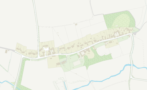
West Leake sits on the winding country road from East Leake to Sutton Bonington and has a very simple plan of one main street. The village is surrounded by agricultural land, with the village of Sutton Bonington further to the west and East Leake to the East. Further to the south is the A6006 which links the village to the main arterial routes the A60 and the A6.
West Leake stands on relatively flat ground, gently sloping down to the east of the village, at between 40 and 50 metres above sea level. The main rock type below the village is Branscombe Mudstone formation within the Mercia Mudstone Group, which gives the topsoil a clay nature.
2.1 The West Leake Conservation Area
This small 9-hectare Conservation Area includes all of the built-up area of West Leake. It enjoys a unity of form and has a rural feel to it.
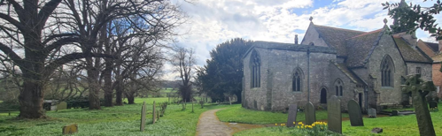
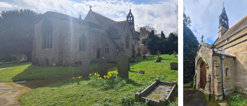
Within the Conservation Area, the small towerless Grade II* (star two) Church of St Helena is 12th, 14th and 15th century and retains its Norman nave, although much restored. To the front of the church is a Grade II Listed lychgate dated circa 1919. This timber structure with its slate roof serves as a memorial to World War One.
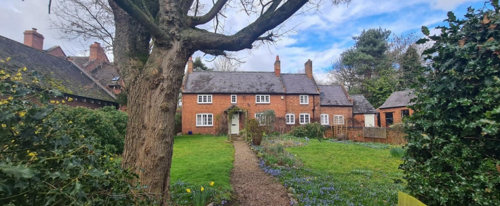
The Old Rectory dated 1723 is one of the oldest houses in West Leake, where on the west wall is said to be the emblem of the Stanhope family.
- Conservation Area Boundary covers - 9.3 hectares (approximate)
- Number of Grade 1 listed buildings - 0
- Number of Grade 2* listed buildings - 1
- Number of Grade 2 listed buildings - 4
A full list of West Leake Conservation Area’s Listed buildings can be found in Appendix 1 Details accurate as of April 2023.
3 Historical Contexts
The first recorded mention of Leake is in the Domesday Book of 1086. However, evidence of Roman occupation can be found in the area, including a likely site of a villa at Stanford on Soar, a temple (currently under Ratcliffe on Soar power station) and isolated finds of coins near ancient trackways.
At the time of the Domesday Survey, Leake is described as among England’s more prosperous estates, having gone up in value since the Conquest while many other estates fell in value. Leake, held by Henry De Ferrers, one of Duke William’s henchmen, had both a church and mill. However, the estate was not subdivided into East and West Leake at that time. While the mill was almost certainly sited at what became West Leake, recent research suggests that the church was at East Leake.
By the mid-12th century, the villages had become separate entities.
The earliest known sub-tenants of the De Ferrers estate were the Touke family, possibly from Calvados, in Normandy. Early in the 13th century the Touke family gifted land in the village to Dale Abbey and granted parts of the estate, including the mill, to the Bugge family, prosperous wool merchants from Nottingham. By 1281 the Bugge family had gained complete control of the lands at West Leake and, later, the rights to the fishery.
August 1318 was a significant month for the village. The then king, Edward II, encamped in the area with his retinue for two days while enroute to Nottingham from Leicester, while a non-aggression treaty between the King and his cousin, Edmund of Lancaster, was drawn up and ratified. The presence of both the King and his cousin, together with their retinues, would have put pressure on the local food resources during a period of already poor harvests. It is likely that random finds of silver half-pennies in the area date from this visit.
In 1325 Geoffrey Bugge, of Bingham inherited his family’s holding in West Leake. A son of Geoffrey, another Geoffrey, married Margaret, the daughter and heiress of Robert de Champaine of Thurleston in Leicestershire. This would have brought considerable wealth into the village as Robert was a descendent of one of Duke William’s henchmen and held a number of estates in the East Midlands. It is possible that the ruined medieval hall, on the moated site, is from this period.
The church contains two outstanding funeral effigies, which have long been rather overlooked, since the male figure is not in armour and they are not made of alabaster, which, although the material was available locally, it did not come into fashion until later. A recent investigation by an architectural archaeologist suggests that they are of the highest quality and would have been very expensive to procure. They may represent Margaret and Geoffrey. Following the death of one of the Bugge family, without heirs, the estate passed through various hands, for a short time belonging to the Manners family of Haddon Hall.
In 1593 most of the estate was acquired by Richard Mansfield, although there were a number of separate small freeholds and a larger one, which belonged to the Stapleton’s of Rempstone. This was subdivided into two, one half being sold to Bartholemew Ragg and the other to George Bird, both from Rempstone, their principal tenants were the Wylde family. The Wylde family holding included Town End Farm and a swathe of land between the village street and the Kingston Brook.
Richard Mansfield’s son, Thomas, a lawyer, consolidated his holdings in the village by purchasing various freeholds, including one which had previously belonged to the Leake family. The village, other than the freeholds, remained in the ownership of three generations of the Mansfield family, until it was inherited by a nephew, Evelyn Chadwick, in 1741. He enlarged his estate by purchasing the Bird Freehold from the absentee Rector and Lord Hastings, the Patron of the Living, who jointly claimed it as Glebe Lands, although they had no right to do so. In the meantime, Chadwick had entered into negotiations to sell what he considered was his estate, or manor, to Lord Middleton of Wollaton Hall.
It is from that date that the first large scale map of the village and its surroundings, now in the Nottinghamshire Archive, was drawn. It took until 1755 and two acts of Parliament for the issue of ownership of the freehold to be resolved. The Bird family and their tenants, the Wylde’s, benefited from the Act of Parliament, in that a new freehold, of 168 acres of land between West and East Leake was created. Much of this land bordered the Kingston Brook and included south facing slopes, ideal for cereal crops. The freehold included a
farmstead, which became Town End Farm. By the mid-19th century, members of the Wilde family were farming approximately 500 acres of land.
The Middleton family owned the Estate for the next one hundred years, at which point it was acquired by the Strutt family, who were later to become the Lords Belper.
3.1 Archaeology
The majority of the village and land to the south and north falls within an Archaeological site which shows the medieval historical core of West Leake, as shown in the historic maps (see page 9). The two fields south and east of West Leake church contain several upstanding earthwork complexes. These include ditches, enclosures, banks, a terraced area and holloway. This site has been identified as the remains of a medieval moated site and associated features. Although no building foundations are evident, some stone walling has
been identified in a ditch. Also, an archaeological excavation by an amateur group in the late 1960s – early 1970s allegedly found structural remains, possibly of a mill. This site is of high archaeological significance.
3.2 Location and Historic Activities
There has been a church at the site of St Helena’s since Saxon times. The oldest part of the church is the north wall of the nave with a tiny deeply recessed window and a blocked-up Norman door, still visible from the outside. The stone effigy and piscina within the south aisle, and the main doorway are the next oldest parts, while both the effigy on the north side of the sanctuary and the figure within the North transept are also Early English. The chancel is of the Decorated period. The nave is unusual due to its long length and on the south side contains an arcade of five arches supported by octagonal columns of the early Perpendicular period. Great rebuilding was undertaken during the fourteenth century when the chancel was enlarged, and the south aisle added to provide a chapel. The clerestory was built to provide additional light within the fifteenth century.
The oldest part of East Leake church, the north wall of the nave, was built in the Saxon style, while the north wall of the nave at St Helena’s church, the oldest standing masonry in West Leake, is believed to date from circa 1100.
West Leake appears to have been an agricultural community linked to the larger adjacent farming community of East Leake. Although controlled by the Lord of the Manor and the church, apart from the presence of the gentry in the late 19th century, the village population consisted of the Rector with his family and servants, the freehold farmer (who eventually sold to Lord Middleton in 1833), tenant farmers, agricultural labourers and their families. All the farm buildings were rebuilt between 1752 and 1785 to a generally standardised form during an improvement programme following a change of ownership. The first farm names recorded are Town
End and Whitehills Farm.
The farms continued to be tenanted until the 1970s, when Village Farmstead and Platts Croft, on the corner of Dark Lane, were sold off for development into housing, with some buildings being demolished and new houses erected. At the same time, more substantial barns were converted into homes. Lord Belper’s Kingston Hall Estates all gradually sold off the farmsteads through the village. In October 1986, Town End Farm, tenanted by the Alsop family, was the last farm to be “taken in” to be managed directly by Kingston Hall
Estates.
In the early 19th Century, a small cottage industry, a basket making shop, was set up by the Mills family, possibly on Wylde land and they also developed Osier beds near “The Star” public house. The Mills family went on to own two far larger basket making works at East Leake.
In 1850 at the instigation of Amelia, the then Lady Belper, a school was built in the village. The school continued in use until 1900’s when declining pupil numbers caused it to be closed, with the pupils being transferred to either Kingston on Soar, or East Leake Elementary schools. In 1966 after many years of limited use, the present Lord Belper gifted the building to the village as a Village Hall to be administered by a group of trustees.
By the beginning of the 1880s, the village church had become very dilapidated, and was consequently largely rebuilt, with the exception of the chancel and the north wall of the nave.
The general configuration of the medieval tofts still remain behind properties on the north side of the street, but over the years some houses have disappeared from the street scene, including cottages on the green and a pair of cottages, next to the churchyard lych-gate, which were burnt out in the 1950’s. Sadly, the thatched roofed Post Office, which has partial stone foundations and a bread oven, was reconstructed in a mock, half-timbered style.
Some new houses have been built fairly recently and Town End Farm has also been redeveloped to provide accommodation. Development has been mainly infill rather than outward.
3.3 Historical Mapping

4 Spatial Analysis
The relationship between open spaces and the built form within a conservation area can be central to its character. This section describes the village’s layout, highlighting the significant views, landmarks and historical focal points. The contribution of open green spaces, trees and other natural elements to the conservation area’s character is also described within this section.
4.1 Plan, Form and Layout
Early maps show that West Leake was a small village, predominantly linear in form following along what it is now known as Main Street, since at least the early 18th century. The size of the village has remained largely unchanged since the late 19th century, with new dwellings generally on infill plots only.
The linear plan form of the village remains, with a single character running through out, although the dwellings to the east of the village tend to front the road more closely than those to the west.
Below is a map that describes the current plan, form and layout of the village/town.
This map is reproduced from Ordnance Survey material with the permission of Ordnance Survey on behalf of the Controller of His Majesty’s Stationary Office © Crown Copyright. Unauthorised reproduction infringes Crown Copyright and may lead to prosecution or civil proceedings.
Rushcliffe Borough Council - 100019419
4.2 Landmarks, Focal Points and Views
The most architecturally significant landmark in West Leake is St Helena’s Church. Built in the 12th century with 14th and 15th century additions, the building was extensively restored in 1878. The church with its church yard has views out into the open countryside, a setting which contributes to the character of the area.
Most of the views out onto open countryside from Main Street are looking south, where the scenic views of rolling hills are visible.

4.3 Open Spaces, Trees and Landscape
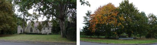
When approached from East Leake, West Leake is characterised by the tree and hedge-lined Main Street. There is a mix of native species, with horse chestnuts to the front of St Helena’s Church of particular importance within the street scene.
There are few public open spaces within the Conservation Area, largely due to the small size of the village and its predominantly linear form. St Helena’s Church is pleasantly set back from the road, with an area of grass and trees to the front. The small area of open space and trees at the junction of Pithouse Lane and Main Street forms an important entrance to the village. The band of trees between the church and Church Farm is particularly significant in the street scene.
Works to Trees
You must contact the Local Planning Authority (LPA), Rushcliffe Borough Council before any works (cutting OR pruning) are carried out to trees within the Wiverton Conservation Area.
Six weeks’ notice is required before any works to trees within the Conservation Area is carried out, even if they are not protected by a Tree Preservation Order (TPO).
If there is a tree which undergoes annual maintenance, include this information with the notice. It may be possible, upon agreement with the tree officer, that only one notice is required to cover the future annual maintenance.
Standard notification forms (a section 211 notice), further information and contact details.
A flow chart of the decision-making process regarding works to trees.
4.4 Public Realm
Boundary treatments are particularly important within Conservation Areas, helping create special character and appearance. West Leake is characterised by a variety of boundary treatments.
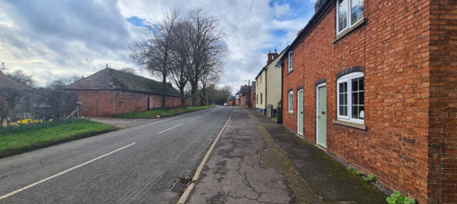
Within the east of the village (and to the north of Main Street), properties are mostly hard up to the pavement and therefore the building elevation adjacent to the road denotes the boundary. Overall, boundary treatments are more varied with railings, brick walls together with trees and hedges. Traditional red brick walls, trees and hedges are the predominant features.
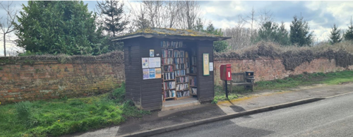
The bus shelter now serves as a book exchange and is a symbol of the community spirit within the village. Since the prior appraisal of 2010, the K6 telephone box that was adjacent to the bin, has been removed.
5 Buildings of the Conservation Area and Key Characteristics
5.1 Building Types and Activity
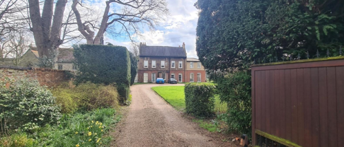
There is an attractive mix of building types, ages and styles within the Conservation Area. There are good examples of vernacular cottages and farm buildings, as well as Georgian and Victorian houses.
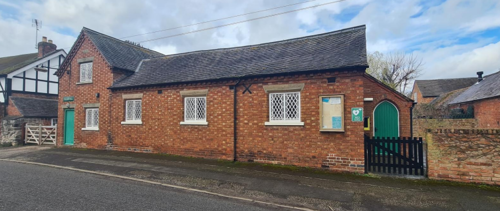
Mid 19th century former school building now used as the village hall provides social amenity as well as character. Brick in Flemish bond with lighter coloured headers, dentillated brickwork to the eaves and a slate roof. The windows have a metal diamond lattice.
5.1.1 Building types and Activity SWOT Analysis
Strengths - what activities/places can you go that make the village/town great?
- None identified
Weaknesses - what activities/places exist that detract from making the village/town great?
- None identified
Opportunities - what activities/places could exist that would village/town even better?
- None identified
Threats - what activities/places would make village/town worse?
- Erosion of rural tranquillity by increased commuter traffic primarily from East Leake to East Midlands Airport, and also by increased air traffic movement overhead.
5.2 Key Characteristics and Building Materials
Before the arrival of the railways in the mid-19th century, building materials were largely locally sourced. Bricks did not often travel far from where they were made, leading to interesting, village specific sizes, colours and styles. Many buildings were also timber framed. Roofs would have originally been made from local materials such as thatch, stone and clay.
Materials:
Walls: Walls of traditional buildings in West Leake are predominantly unrendered red brick, with Flemish bond being common in the older buildings, sometimes using coloured bricks to enhance the pattern of the bond. Roofs are predominantly plain clay tiles, clay pantiles and Welsh slate, with the latter becoming more readily available with the introduction of the railways in the mid to late 19th
century.
Where original or traditional windows survive, they are predominantly either timber sliding sash or timber casements, with slender glazing bars. These often create a symmetrical façade and make a significant contribution to the character and appearance of the Conservation Area.
Key Characteristics / Architectural Features:
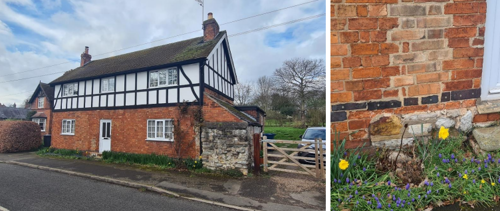
The large foregardens of the houses on the west of Main Street contribute a feeling of openness and greenery, while a pair of modest red brick cottages on the right standing hard on the public footpath add interest to the public realm, as well as contributing to the aesthetic appeal of the area with their simplicity and symmetry.
5.2.1 Key Characteristics SWOT Analysis
Strengths - what is it about most existing buildings that looks good?
- Attractive street scene
- Historic and architectural merit of buildings
- Absence of overhead lines
Weaknesses - what is it about most existing buildings that does not look good?
- Unsympathetic modern development.
- Unsightly utilities structures, including junction boxes, telephone poles and aluminium lamp posts (following the loss of the Victorian style lamp posts)
Opportunities - what could make existing buildings (or new builds) look good and contribute to the character of the area?
- Improve or replace unsympathetic utilities structures.
Threats - what could make existing buildings (or new builds) look worse and detract from the character of the area?
- Residents not applying for planning permission for their development, and consequently eroding the character of the area.
5.3 Listed buildings
Buildings on the Government’s List of Buildings of Special Architectural or Historic Interest are called “Listed” buildings and are protected by law. Consent is required from Rushcliffe Borough Council before any works of alteration, extension, or demolition can be carried out on any listed building.
Further information can be found in Rushcliffe Borough Council’s publication Listed Buildings in Rushcliffe.
The complete up-to-date list of the Secretary of State’s Statutory List of Buildings of Special Architectural Interest or Historic Interest.
Names of the Listed Buildings and structures in West Leake Conservation Area (correct as of March 2023) are detailed in Appendix 1. All Listed Buildings are shown on the Townscape Appraisal plan, but some smaller structures such as gravestones may not be shown.
West Leake Conservation Area has five listed buildings and structures: the Old Rectory (Grade II); the Church of St Helena (Grade II*), shown below left; the lychgate (Grade II); the sundial (Grade II), which was unfortunately vandalised in the early 2010s, so only the pedestal remains in St. Helena’s churchyard. The other listed building is 55 Main Street (Grade II).
The small towerless church of St Helena is 12th, 14th and 15th century and retains its Norman nave, although it has been much restored. At the entrance to the churchyard stands the circa 1919 lychgate. This timber structure with its slate roof serves as a memorial to World War One. The Old Rectory, dated 1723, is one of the oldest houses in West Leake and its most imposing Georgian building. The emblem of the Stanhope family is said to be on the west wall.
Mid-18th century red brick house with slate roof. Central doorway with panelled door, overlight and open porch. Either side are single tripartite glazing bar casements under segmental arches.
5.4 Key Unlisted Buildings
The Conservation Area contains a large number of unlisted buildings and structures that make a positive contribution to the character and appearance of the Conservation Area. This may be because of their age, architectural style, former function, or general contribution to the townscape. Planning guidance stresses the importance of protecting such buildings. Key unlisted buildings are highlighted in Appendix 2 - Conservation Area Boundary and Townscape Appraisal Map. However, it is important to stress that nearly all the buildings
within a Conservation Area can make a positive contribution to the townscape in some way.
x6 images
6 Generic Management Plan for Conservation Areas in Rushcliffe
6.1 Introduction
In carrying out its planning functions, the Borough Council is required in law to give special attention to the desirability of preserving or enhancing the character or appearance of Conservation Areas. The Management Plan for a Conservation Area is a tool to ensure the special character of the area is preserved and enhanced. The management plans aim to:
- Outline a strategic management proposal for the preservation and enhancement of the West Leake Conservation Area.
- Act as a guide for professionals and residents alike regarding:
- features of value, worthy of preservation;
- characteristics worthy of preservation;
- opportunities for enhancement;
- development proposals which preserve and enhance the special character of the area.
- Inspire community commitment to conservation principles and reporting.
6.2 National and Local Policies and Guidance
There is a duty to formulate and publish management plans setting out policies and proposals for the preservation and enhancement of Conservation Areas. Many of these policies and proposals are common to all Conservation Areas, and these are set out in this document. The Central Government Guidance and Local policies applicable to Conservation Areas include:
- Rushcliffe Local Plan Part 1: Core Strategy, with a specific focus on:
- Design and Enhancing Local Identity [in part]
- Historic Environment
- Rushcliffe Local Plan Part 2: Development Policies, with a specific focus on:
- Conserving and Enhancing Heritage Assets
- Development Affecting Archaeological Sites
- The National Planning Policy Framework (NPPF), particularly, but not exclusively the chapter on Conserving and Enhancing the Historic Environment.
- The National Planning Practice Guidance (NPPG) (updated 2021 and subject to continual review)
- By Design: Urban Design in the Planning System – Towards Better Practice (2000)
- The Planning (Listed Buildings and Conservation Areas) Act 1990
- Historic England “Historic England Advice Note 1: Conservation Area Designation, Appraisal and Management”
The council will utilise the full range of strategic policy and guidance documents to ensure that development in West Leake Conservation Area is of a standard that enhances the amenity of the local area. The council will always look to use the most up-to-date versions of the document.
Supplementary documents may be issued for individual Conservation Areas where specific policies or proposals are needed.
6.3 Article 4 Directions
There are extra consents required in Conservation Areas. For example, in addition to the general control of development, you will
need to get permission for
- Any additions or alterations to the roof (for example, dormer windows)
- The installation of satellite dishes on chimneys, roofs or walls fronting a highway
- Any extension which extends beyond the side of the original dwelling house
- Any extension of more than one storey that extends beyond the rear wall of the original dwelling house
- Cladding the exterior of the dwelling
- Any demolishing of a building or part of a building that has a volume over 115 cubic metres
Article 4 of the Town and Country Planning (General Permitted Development) Order 1995, allows planning authorities to restrict
some permitted development rights within particular areas. This does not necessarily prevent development or change taking place
but enables the Local Authority to manage the design and detailing of the works, and potentially grant permission subject to appropriate conditions. The use of Article 4 Directions will be proposed where it is considered appropriate following the completion of each Area Appraisal across the Borough.
Details of Article 4 Directions for West Leake Conservation Area
There are currently no Article 4 Directions for West Leake Conservation Area.
6.4 Building Design
Mimicking the local vernacular is not the only way to ‘fit in’ with the character of a conservation area. National policy makes clear that contemporary designed, provided it is sympathetically designed, cannot be dismissed as an option. Therefore, good contemporary design will be encouraged where it respects the context’s character, scale and massing. This must be demonstrated in the Design and Access Statement submitted with any planning application.
Extensions to buildings in Conservation Areas should respect:
- The key characteristics of the original building, including scale, mass, materials and proportions
- The contextual setting and character of the Conservation Area
Copying like for like can devalue and destroy the ability to “read” historic change, and dilutes our historic heritage. Pastiche designs, incorporating poor imitations of other styles, will be resisted, particularly where they incorporate details which are not locally appropriate. Careful high-quality replication may be required in a few very sensitive locations.
In particularly sensitive locations, such as uniform terraces, exact replication may be necessary to maintain compositional unity. In that case, attention to details, choice of materials and high-quality workmanship are the keynotes. However, in some cases, a direct relationship is not impossible. For example, Flemish Bond brickwork cannot be replicated in cavity walls, and narrow lime mortar joints cannot be replicated in modern metric brickwork.
Where a new building is appropriate, on infill sites or where an existing building detracts from the character of the area, the opportunity should be taken to re-establish the streetscape, reinforce enclosure, open up distant vistas or views of landmarks or hide unsightly views.
“New and old buildings can coexist happily without disguising one as the other, if the design of the new is a response to urban design objectives” (DETR – “By Design”, p19).
As with extensions, good contemporary design which respects local character, and the context of the site will be encouraged.
All new buildings should respond appropriately to the existing frontage and normally follow the established building line. Development or redevelopment will normally be resisted if:
“it blocks important views identified in the individual appraisals, uses important open spaces identified in the appraisals, adversely affects the setting of any Listed or key buildings, fails to maintain or re-establish the streetscape where appropriate dominates its Conservation Area background fails to recognise the context of
the site destroys important features identified in the individual appraisals such as boundary walls, fences,
hedgerows or trees”
Where the quantity of contemporary schemes in a small area becomes significant and outnumbers older buildings within the area, further contemporary schemes could fundamentally shift the architectural character of the area and thus be harmful, even if well designed as an individual project.
New development that stands out from the background of buildings may be appropriate in exceptional circumstances if it contributes positively as a landmark to enhance the street scene, to highlight a corner or to signal a visual change of direction such as along a curving vista.
Any external lighting should be carefully designed and sited to minimise light pollution. Energy producing or saving devices are generally welcomed by the Council, but careful consideration is required when these are to be located in a Conservation Area and some may require planning permission. In particular, they should be positioned to minimise their impact on the building and on the local amenity.
6.5 Publicity and Knowledge Transfer
Ambiguity about additional controls within a Conservation Area raises the likelihood of inappropriate developments occurring which
may damage the integrity of the conservation area designations.
Efforts have been made to engage local community groups in the development and review of the character appraisals. Empowering
communities to define the special architectural and historic interest of the Conservation Area aims to raise awareness.
Whether the appraisal took a community-led or a council-led approach, upon reviewing all Conservation Areas, the public were invited to ask questions and comment during a public consultation. A consultation event also aimed to diminish any ambiguity about
restrictions within a Conservation Area and increase the likelihood of sensitive and appropriate developments, maintaining the character
of the area.
The council recognise the potential issues of turnover in residency and ownership of properties in the conservation area. Therefore,
Rushcliffe Borough Council will periodically use their media outlets to highlight conservation area designations and the significant,
related planning controls.
The approach taken within West Leake Conservation Area was Council Led. The consultation period took place between the following dates 26/1/2024 – 20/02/2024
The date of the Consultation Event 12/02/2024.
If there are any queries about conservation areas, please email conservationareas@rushcliffe.gov.uk
6.6 Public Realm
General maintenance and upkeep to the public realm may include fixing damage to roads and pavements, and fixing issues with street lighting. Issues such as these can impact the quality of the Conservation Area.
The council aims to encourage works to the public realm that are in keeping with, or actively enhance the conservation area. Rushcliffe Borough Council can only advise on work within the public realm that does not require planning permission (for example work completed by statutory undertakers, such as the Highways Authority). In these instances, Rushcliffe borough council cannot prevent such work.
Nottinghamshire County Council are responsible for repairs to roads, pavements and street lighting. Report issues of repairs to roads, pavements and street lighting to Nottinghamshire County Council online.
Rushcliffe Borough Council will continue to undertake their duties in maintaining the public realm. Vandalism, fly tipping and street cleaning are all the responsibility of Rushcliffe Borough Council. Report issues to Rushcliffe Borough Council online.
You must contact the Local Planning Authority (LPA), Rushcliffe Borough Council, before any works (cutting OR pruning) are carried out to trees within the Wiverton Conservation Area
Six weeks’ notice is required before any works to trees within the Conservation Area is carried out, even if they are not protected by Tree Preservation Order (TPO).
Standard notification forms (a section 211 notice) - further information and contact details.
A flow chart of the decision-making process regarding works to trees.
6.7 Boundary Treatments
Where there is a proposal for a new boundary treatment to be installed, the council would encourage the use of boundary treatments within the area.
Within conservation areas, planning permission is required to alter, maintain, improve, take down or build any new gate, fence, wall or other enclosure with:
- A height of one metre or more if next to a highway (including a public footpath or bridleway), waterway or open space; or
- A height of two metres or more elsewhere.
Where planning permission is required to remove a wall, Rushcliffe Borough Council will aim to protect those boundary walls and fences that have been identified as positively contributing to the area.
Hedgerows are significant habitats for wildlife in lowland Britain. Regulations are intended to protect important hedges in the countryside. The policy applies to hedges that are more than 20m long, (or less if connected to another hedge) on or adjacent to:
- Land used for agriculture or forestry, including the keeping of horses or donkeys
- Registered common land and village greens
- Local Nature Reserves and Sites of Special Scientific Interest.
The policy does not apply if the hedge is within or on the boundary of the curtilage of a house.
6.8 Buildings at risk
A few of the important buildings across the various Conservation Areas are currently vacant or not in regular use, which may lead to some being “at risk” of neglect or decay.
The Council will encourage and advise on renovation and repair work that is sensitive to the original or traditional historic character of the building and retains original features. The council will monitor the opportunity and potential for grant aid schemes to encourage the basic maintenance work necessary to ensure that key buildings within the conservation area are structurally sound and weather tight. However, given the current financial climate and outlook, such schemes are unlikely in the short to medium term.
There is a presumption against the demolition of buildings which contribute to the character of the area unless there are exceptional circumstances. It would benefit both the physical form and the function of the Conservation Area if these buildings were repaired, maintained and brought back into use.
Where the poor condition of a building or structure is as a result of neglect and lack of maintenance by its owner there is no requirement for the Borough Council to take its deteriorated condition into account when deciding whether demolition is appropriate. This is to avoid rewarding the deliberate neglect of buildings by representing such action as a way to obtain planning permission for demolition and redevelopment.
6.9 Enforcement
Rushcliffe Borough Council will, from time to time, assess and monitor changes in the appearance and condition of West Leake Conservation Area. This will ensure that where necessary enforcement action can be taken promptly to deal with problems as they arise.
Where co-operation cannot be gained by any other means, Rushcliffe Borough Council has the ability to use additional enforcement powers to tackle particular issues within conservation areas. The Council may take formal action if the condition of any building (listed or unlisted) which makes a positive contribution to the character of the Conservation Area is considered to be at risk.
The council will work in accordance with their enforcement policy, which aims to provide an efficient enforcement service in support of the Council’s statutory planning service. Rushcliffe Borough Council’s enforcement actions will remain transparent, consistent, and proportionate, as it is recognised that effective controls over unauthorised development assists in conserving the natural and built environment whilst helping to protect the quality of people’s lives and maintaining the Council’s integrity.
7 Appendix 1 – Listed Buildings (as of March 2023)
Grade: 2
Listing entry number: 1260026
National grid reference: SK 52913 26554
Location: 55, Main Street
Grade: 2
Listing entry number: 1242472
National grid reference: SK 52724 26422
Location: The Old Rectory, Main Street
Grade: 2*
Listing entry number: 1242473
National grid reference: SK 52748 26428
Location: Church Of St Helena, Main Street
Sundial in Churchyard of Church of St Helena, Single Metre South of The Chancel
Grade: 2
Listing entry number: 1260027
National grid reference: SK 52769 26422
Location: Sundial In Churchyard of Church of St Helena, Single Metre South of The Chancel, Main Street
Lychgate at Entrance to Churchyard of Church of St Helena
Grade: 2
Listing entry number: 1242474
National grid reference: SK 52771 26464
Location: Lychgate At Entrance to Churchyard of Church of St Helena, Main Street
*The titles of these listings may not make it clear that all listed buildings always include all attached structures and extensions, regardless of age, and all detached outbuildings built before 1 June 1948 which are, or were at the time of listing, ancillary to the function of the primary listed building and were in the same ownership at the time of listing.
For example, when a house is listed, the listing will apply to extensions, porches, detached historic stables, barns, wash houses, privies etc. Such outbuildings and extensions are only exempt from the provisions of listing where the listing specifically excludes them. Appendix 2 - Conservation Area Boundary and Townscape Appraisal Map.
8 Appendix 4 – Conservation Area Boundary and Townscape Appraisal Map

The West Leake Townscape Map above shows:
- Locations of listed buildings
- Locations of key unlisted buildings
- Open space
- Locations of trees, hedges, and significant hedges and fences
- Viewpoints
Conservation Areas
- Bingham Conservation Area
- East Bridgford Conservation Area
- East Leake Conservation Area
- Hawksworth Conservation Area
- Hickling Conservation Area
- Ruddington Conservation Area
- Thoroton Conservation Area
- Wiverton Conservation Area
- Langar Conservation Area
- West Leake Conservation Area
- Whatton in the Vale Conservation Area
- Costock Conservation Area
- Sutton Bonington Conservation Area
- Upper Saxondale Conservation Area
- Wysall Conservation Area
- Bradmore Conservation Area
- Car Colston Conservation Area
- Scarrington Conservation Area
- Orston Conservation Area
- Flintham Conservation Area
- Edwalton Conservation Area
- Aslockton Conservation Area
- Bunny Conservation Area
- Granby Conservation Area
- Keyworth Conservation Area
- Thrumpton Conservation Area
- Normanton on the Wolds Conservation Area
- Upper Broughton Conservation Area
- Kneeton Conservation Area
- Colston Bassett Conservation Area
- Cropwell Bishop Conservation Area