Step into Bingham
Rushcliffe Borough Council (RBC) is encouraging residents to walk, wheel or cycle when making journeys into Bingham and other town centres in the Borough for a healthier and greener future.
Active travel methods boost physical activity and provide numerous health and wellbeing benefits, such as maintaining a healthy weight, reducing stress, and improving heart health. It can also help save money by lowering travel costs compared to driving and parking.
By choosing to leave the car at home, residents can help to play their part in reducing their carbon footprint by improving air quality, reducing pollution and preventing traffic congestion.
Working in conjunction with Ridewise, RBC have produced a new active travel map which highlights the safest walking routes from each residential area of Bingham into the town centre. The map also provides details of bus routes and stops throughout Bingham, which provide a range of key services for commuting and leisure.
This maps can be viewed below, and is available via download here - Step into Bingham map
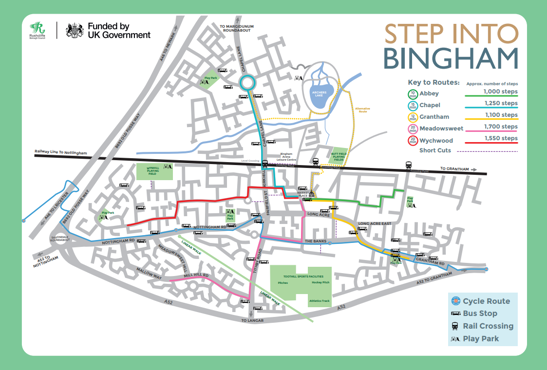
Routes:
Abbey - 10 minute walk - approximately 1,000 steps
Chapel - 15 minute walk - approximately 1,250 steps
Grantham - 12 minute walk - approximately 1,100 steps
Meadowsweet - 20 minute walk - approximately 1,700 steps
Wychwood - 20 minute walk - approximately 1,550 steps
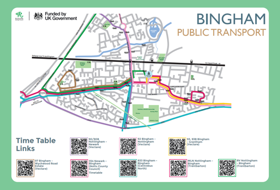
Bus Services:
90 / 90B - Nottingham - Newark (Vectare)
92 - Bingham - Nottingham (Vectare)
93 / 93B - Bingham - Grantham (Vectare)
97 - Bingham - Wychwood Road Estate (Vectare)
354 - Newark - Bingham (Notts County Council)
833 - Bingham - Bingham (Centrebus North)
MLN - Nottingham - Bingham (Trentbarton)
RV - Nottingham - Bingham (Trentbarton)
Larger versions of the Step into Bingham map will also be installed in Newgate Street car park for walkers, wheelers and cyclists to use and plan their routes to work or home!